Send Message
products

High Accuracy GPS Base RTK GNSS Receiver ​For Land Survey Kolida K1 Pro

Basic Information
Place of Origin: China
Brand Name: Kolida
Certification: CE
Model Number: K1 Pro
Minimum Order Quantity: 1pcs
Price: Negotiable
Packaging Details: suitcase and carton
Delivery Time: 3-7day
Payment Terms: T/T, Western Union
Supply Ability: 10pcs/day
Detail Information
Channels: 336 Channels Model: Kolida K1 Pro
GPS: L1, L1C, L2C, L2P, L5 GLONASS: G1, G2, G3
Operating Temperature: -25℃ ~ +65℃ Humidity: 100% Non-condensing
Waterproof/Dustproof: IP68 Standard Frequency Range: 410 - 470MHz
Operating System: Linux Buttons: Single Button
Indicators: 5 LED Indicators
High Light:

GPS Base RTK GNSS Receiver

,

Land Survey GPS GNSS Receiver

,

K1 Pro RTK GPS Receiver


Product Description

High Performance Cheap Price High accuracy GPS Base and Rover RTK GNSS Land Survey Product Kolida K1 Pro:
 
Product Description
 

• Star-Fill Technology Now Available, to Overcome "Non-signal" Spots
• Star-link none-base positioning service (optional)
• Inertial Measurement + GNSS Positioning, Faster & Reliable
• OLED Color Screen, User Friendly Operation
• 10,000 mAh battery, A Whole-day Working With only One Recharge

Star-Fill, Save the signal-loss
This new function will let you continue working a few minutes when radio or mobile signal is becoming very poor or even lose in blind area, the accuracy is down to 2cm.
Work Faster, Wait Less
The Maxwell 7 GNSS engine inside K1 PRO provides an ultra-fast positioning speed, typically it starts tracking satellite signal within 5 seconds after turning on, coordinate can be acquired within 10 seconds.
Star-Link Correction Infinite Freedom
2cm Accuracy Star-Link correction service is available now! After subscribing to it, surveyors can work almost anywhere in the world without a base station or VRS network
Intertial Measurement, Fast and Flexible
The newly developed inertial tilt survey is no more affected by the earth's magnetic field and requires no correction. The maximum tilt angle has been improved to 60 °, measurement speed is increased by over 30%.

High Accuracy GPS Base RTK GNSS Receiver ​For Land Survey Kolida K1 Pro 0High Accuracy GPS Base RTK GNSS Receiver ​For Land Survey Kolida K1 Pro 1High Accuracy GPS Base RTK GNSS Receiver ​For Land Survey Kolida K1 Pro 2

Technical parameter
 
Specification


GNSS Features
Channels
336
GPS
L1, L1C, L2C, L2P, L5
GLONASS
G1, G2, G3
 
BDS
BDS-2: B1I, B2I, B3I
BDS-3: B1I, B3I, B1C, B2a, B2b*
GALILEOS
E1, E5A, E5B, E6C, AltBOC*
SBAS
L1*
IRNSS
L5*
QZSS
L1, L2C, L5*
MSS L-Band (Reserve)
 
Positioning output rate
1Hz~20Hz
Initialization time
< 10s
Initialization reliability
> 99.99%


Positioning Precision
Code differential
GNSS positioning
Horizontal: 0.25 m + 1 ppm RMS
Vertical: 0.50 m + 1 ppm RMS
GNSS static
Horizontal: 2.5 mm + 0.5 ppm RMS
Vertical: 5 mm + 0.5 ppm RMS
Real-time kinematic
Horizontal: 8 mm + 1 ppm RMS
(Baseline<30km)
Vertical: 15 mm + 1 ppm RMS
SBAS positioning
Typically < 5m 3DRMS
RTK initialization time
2 ~ 8s
 
IMU tilt compensation
Additional horizontal pole tip uncertainty
typically less than 10mm + 0.7 mm/° tilt down to 30°
IMU tilt angle
0° ~ 60°


Hardware Performance
Dimension
130.5mm(φ) × 84mm(H)
Weight
850g (battery included)
Material
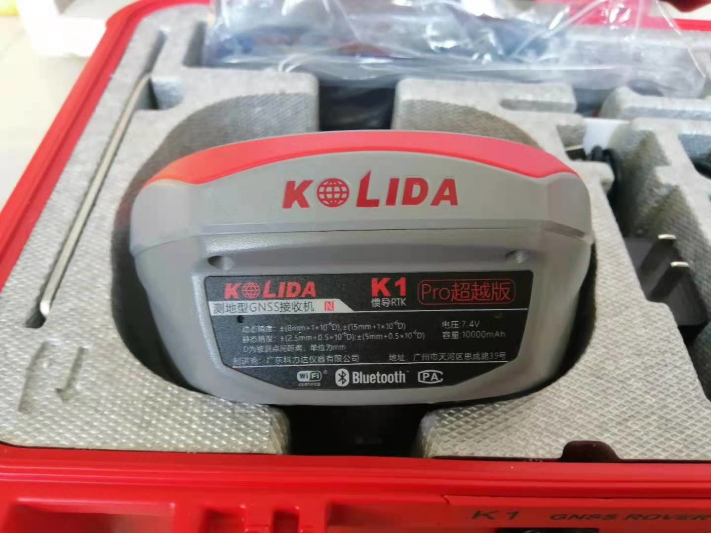
Magnesium aluminum alloy shell
Operating temperature
-25℃ ~ +65℃
Storage temperature
-35℃ ~ +80℃
Humidity
100% Non-condensing
 
Waterproof/Dustproof
IP68 standard, protected from long time immersion to depth of 1m IP68 standard, fully protected against blowing dust
Shock/Vibration
Withstand 2 meters pole drop onto the cement ground naturally
Power supply
6-28V DC, overvoltage protection
Battery
Inbuilt 6800mAh rechargeable, removable Lithium-ion battery
Battery life
Single battery: 16h (static mode), 8h (Base + UHF), 12h (Rover + UHF), 15h (Rover + Bluetooth)


Communications
I/O Port
5PIN LEMO external power port + Rs232
Type-C interface (charge + OTG + Ethernet)
1 UHF antenna interface
SIM card slot (Micro SIM)
Internal UHF
Radio receiver and transmitter, 1W/2W/3W switchable
Frequency range
410 - 470MHz
Communication protocol
Farlink, Trimtalk450s, SOUTH, SOUTH+, SOUTHx, HUACE, Hi-target, Satel
Communication range
Typically 8km with Farlink protocol
Cellular mobile network
4G cellular module standard, customizable 5G module
Bluetooth
Bluetooth 3.0/4.1 standard, Bluetooth 2.1 + EDR
NFC Communication
Realizing close range (shorter than 10cm) automatic pair between receiver and controller (controller requires NFC wireless
communication module else)
 
 
WIFI
Modem
802.11 b/g standard
WIFI hotspot
Receiver broadcasts its hotspot form web UI accessing with any mobile terminals
WIFI datalink
Receiver can transmit and receive correction data stream via WiFi datalink


Data Storage/Transmission


Storage
8GB SSD internal storage standard, extendable up to 64GB
Automatic cycle storage (The earliest data files will be removed automatically while the memory is not enough)
Support external USB storage
The customizable sample interval is up to 20Hz
Data transmission
Plug and play mode of USB data transmission
Supports FTP/HTTP data download


Data format
Static data format: STH, Rinex2.01, Rinex3.02 and etc.
Differential data format: CMR, SCMRx, RTCM 2.1, RTCM 2.3, RTCM 3.0, RTCM 3.1, RTCM 3.2
GPS output data format: NMEA 0183, PJK plane coordinate, Binary code, Trimble GSOF
Network model support: VRS, FKP, MAC, fully support NTRIP protocol


Sensors
Electronic bubble
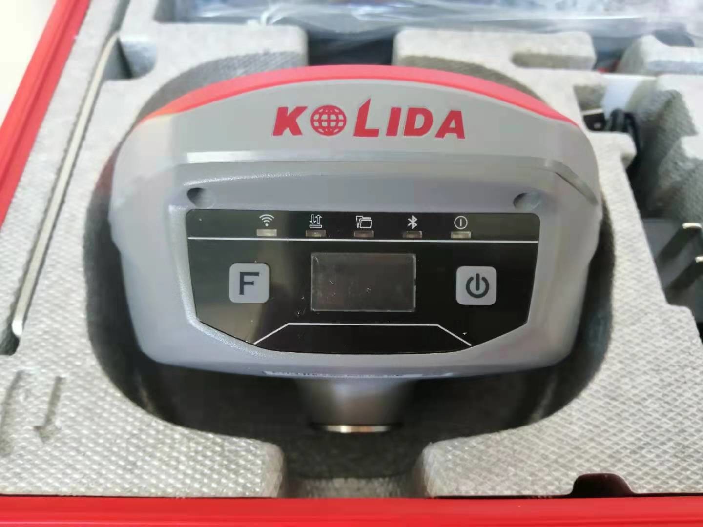
Controller software can display electronic bubble, checking leveling status of the carbon pole in real-time
IMU
Built-in IMU module, calibration-free and immue to magnetic interference
 
Thermometer
Built-in thermometer sensor, adopting intelligent temperature control technology, monitoring and adjusting the receiver
temperature


User Interaction
Operating system
Linux
Buttons
Single button
Indicators
5 LED indicators
 
Web interaction
With the access of the internal web interface management via WiFi or USB connection, users are able to monitor the receiver status
and change the configurations freely
 
Voice guidance
It provides status and operation voice guidance, and supports Chinese/English/Korean/Spanish/Portuguese/Russian/Turkish
 
Secondary development
Provides secondary development package, and opens the OpenSIC observation data format and interaction interface definition
Cloud service
The powerful cloud platform provides online services like remote manage, firmware update, online register and etc.


Packaging & Shipping


Economical 2


Our Services

1. Warranty: 12 months warranty is offered for survey equipment. 6 months warranty offered for survey accessory. Warranty comes in effective from the day your receive good.
2. Repair in warranty: We are responsible for supplying new parts for repairing. Round way freight will be charged by us. If it is necessary, product will be required to send back to our service center to be repaired, round way freight is charged by us. Our engineer will repair in your office for special case.
3. Repair out of warranty: We will offer related parts at commercial cost. Freight will be shared by us
4. Training and calibration: Our engineer is qualified for training and calibration for GNSS and Total Station on site. We offer this service to bulk order while customer has requirement.
5. Technical support is offered 24/365.


Company Information

Shanghai Galxy International Trade company, Ltd. combining with developing, researching and producing. Our company is located in Pudong Developing Zone, and has two subsidiary companies: Shanghai Galaxy International Trade Co., Ltd. and Mato Opto-electrical High-tech Company. Our company has researching center and factory in Changzhou.

Our main products are as following: total station, electronic theodolite, automatic level, laser level, rotation laser, GPS, distance laser sensor and accessories, such as tripod, prism, pole, staff and USB cable for total station. Our company designs software for many domestic and oversea factories, for example, Boif, TJOP, Stanley, and Cst-Berger. We have powerful capacity in technical research, and the products we designed have advanced technology and steady performance. The non-prism total station and the absolute coding measure instrument we developed and produced have very competitive points in the measure instrument market.

We expect that we could cooperate with more business partners from all over the world. In addition, we can do OEM service for companies or dealers that want to find better producers in China.

Our goal is to produce the best surveying instruments in the world.

Our target is to globalize the market, internationalize the quality and maximize the profit!
Economical 2

FAQ

1. What kind payment method we accept?
T/T, L/C at sight, Western Union, Trade Assurance on Alibaba
Note: Customer will be requested to pay 4% transaction fee upon total amount charged by EBAY.
2. How can you guarantee payment safety ?
Our company supports TRADE ASSURANCE service. If you will choose payment through ALIBABA TRADE ASSURANCE service, you payment will be guaranteed. Because we are not able to receive payment until you confirm goods receipt.
3. What kinds of shipment for goods and how long time it takes ?
Our company supports DHL, FEDEX, UPS, TNT, CHINA POST, by sea and other methods. Shipping time is 3-5 days from payment receipt.
4. Does your company ship battery or not ?
Our company can receive battery order and ship to customer normally, except a few special countries.
5. Do you have other items not displayed on your website ?
Yes, our company supplies full survey range products. If you are looking for product not displayed on our website. Please contact us freely. We will reply you on time.


Contact Details
Lydia Zhu

Phone Number : +8618017639312

WhatsApp : +8618301928717