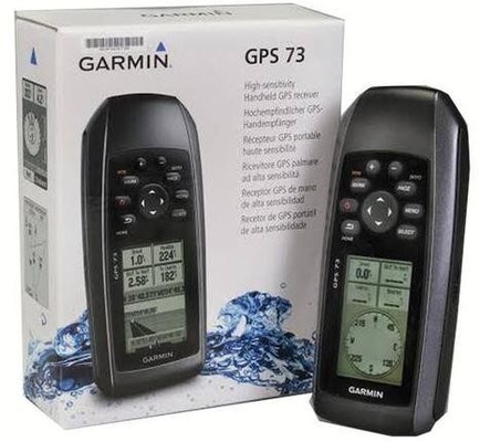
Product Description:
Physical & Performance
Physical dimensions: 2.6" x 6.0" x 1.2" (6.6 x 152.2 x 3.0 cm)
Display size, WxH: 1.4" x 2.1" (3.6 x 5.4 cm); 2.6" diag (6.6 cm)
Display resolution, WxH: 128 x 160 pixels
Display type: 4 level gray LCD
Weight: 7.2 oz (203.1 g) with AA batteries
Battery: 2 AA batteries (not included)
Battery life: +18 hours
Water rating: IPX7
High-sensitivity receiver: Yes
Interface: Serial and USB
Features:
Maps & Memory
Waypoints/favorites/locations: 1,000
Routes: 50
Track log: 10,000 points, 100 tracks
Features:
Floats: Yes
Hunt/fish calendar: Yes
Sun and moon information: Yes
Area calculations: Yes
Technical Parameters:
Easy-to-use GPS Handheld Navigator
High-sensitivity GPS marks and stores 1,000 waypoints and 100 tracks
Marks your favorite locations to easily navigate back to them
Garmin SailAssist™ for GPS 73 includes virtual starting line, heading line, countdown timers and tack assist
Sunrise/sunset, estimated time of arrival, other calculations and marine data
Built-in backlight
This easy-to-use handheld is the perfect navigational solution for boats, sailboats or small watercraft that do not have a chartplotter. It’s also ideal as an important emergency navigation backup for all vessels. Its high-sensitivity GPS marks and stores 1,000 waypoints and 100 tracks so you can navigate right back to them. Use on land or water — it floats! Features SailAssist, including virtual starting line, heading line, countdown timers and tack assist.
Quickly Acquires Satellites
High-sensitivity GPS receiver quickly locks onto GPS signals and tracks your location even in challenging locations, such as deep canyons or under heavy tree cover.
Mark Important Waypoints
Whether it’s a hot fishing spot or a lobster pot, you can mark and store 1,000 waypoints and 100 tracks to navigate to and from time and time again.
SailAssist
SailAssist helps you sail more effectively with heading line and tack assist. Tack assist lets you know when to tack based on whether your boat is getting headed or lifted compared to the boat's optimal tacking angle. For those who like to race, there’s virtual starting line and countdown timer to make sure you cross the starting line at the right time.
Store Important Data
GPS 73 is NMEA 0183 compatible. To transfer data to your device, it easily connects to your computer via USB. If you're into boating, hunting or fishing, you can use the built-in celestial data, which includes sunrise/sunset times and a hunting and fishing calendar, estimated time of arrival, other calculations and marine data.
High-contrast Display
GPS 73 has an intuitive user interface with dedicated back-lit buttons for quick and easy operation. Its high-contrast display makes it easy to read in all lighting conditions.
Applications:
The Garmin GPS73 RTK GPS System is a versatile and reliable navigation tool designed for a wide range of applications and scenarios. With its precise positioning capabilities, this product is ideal for various industries and activities where accurate location data is essential. Here are some key product application occasions and scenarios:
1. Surveying and Mapping: The Garmin GPS73 is perfect for professionals in the surveying and mapping industry. Its Real-Time Kinematic (RTK) technology allows for highly accurate data collection, making it an essential tool for creating detailed maps and surveys.
2. Outdoor Adventures: Whether hiking, camping, or geocaching, the GPS73 is a valuable companion for outdoor enthusiasts. With a water rating of IPX7, it can withstand harsh weather conditions, ensuring reliable performance in various outdoor environments.
3. Marine Navigation: Boaters and fishermen can benefit from the GPS73's navigation features, including waypoints, routes, and a clear display resolution of 128 x 160 pixels. Store important data such as favorite fishing spots and navigation routes for safe and efficient marine travel.
4. Geotagging: Photographers and researchers can use the GPS73 to geotag photos and document locations accurately. With the ability to store up to 1,000 waypoints, users can easily track and record important data for future reference.
5. Field Work: Whether in agriculture, forestry, or construction, the Garmin GPS73 is a valuable tool for fieldwork applications. Its lightweight design, weighing only 7.2 oz with AA batteries, makes it easy to carry and use in various outdoor settings.
6. Emergency Response: In critical situations where precise location data is crucial, the GPS73 can be a lifesaving tool for emergency responders. With the ability to store up to 50 navigation routes, users can quickly navigate to different locations with confidence.
Overall, the Garmin GPS73 RTK GPS System is a reliable and versatile product that caters to a wide range of industries and activities. Its accurate positioning capabilities, durable design, and user-friendly features make it a valuable tool for storing important data and navigating with confidence.
Customization:
Customize your Garmin GPS73 RTK GPS System to suit your needs:
- Store Important Data with a navigation track log of 10,000 points and 100 tracks.
- Enjoy the High-contrast Display with a resolution of 128 x 160 pixels for clear visibility.
- Benefit from the SailAssist feature on the 1.4" x 2.1" (3.6 x 5.4 cm) display, 2.6" diag (6.6 cm).
- Explore with peace of mind with a battery life of over 18 hours.
- Made in the US, the Garmin GPS73 weighs 7.2 oz (203.1 g) with AA batteries.
Support and Services:
Our RTK GPS System product comes with comprehensive Product Technical Support and Services to assist customers with any issues they may encounter. Our team of experienced technicians is available to provide troubleshooting assistance, software updates, and guidance on how to optimize the performance of the system. In addition, we offer training sessions and on-site support to ensure that customers can make the most of their RTK GPS System. Our goal is to provide reliable and efficient support services to help our customers achieve their desired outcomes.

 Your message must be between 20-3,000 characters!