Product Description:
Physical & Performance
Physical dimensions: 2.6" x 6.0" x 1.2" (6.6 x 152.2 x 3.0 cm)
Display size, WxH: 1.4" x 2.1" (3.6 x 5.4 cm); 2.6" diag (6.6 cm)
Display resolution, WxH: 128 x 160 pixels
Display type: 4 level gray LCD
Weight: 7.2 oz (203.1 g) with AA batteries
Battery: 2 AA batteries (not included)
Battery life: +18 hours
Water rating: IPX7
High-sensitivity receiver: Yes
Interface: Serial and USB
Features:
Maps & Memory
When it comes to navigation and location features, this device has a variety of capabilities. It can store up to 1,000 waypoints, favorites, and locations. Additionally, you can create and save up to 50 different routes, allowing for efficient trip planning. The track log feature is also impressive, enabling you to record up to 10,000 points across 100 tracks.
Some of the key features of this device include the ability to keep floats, a hunt/fish calendar, and provide sun and moon information. Furthermore, it offers area calculations, making it a versatile tool for outdoor enthusiasts and adventurers.
Technical Parameters:
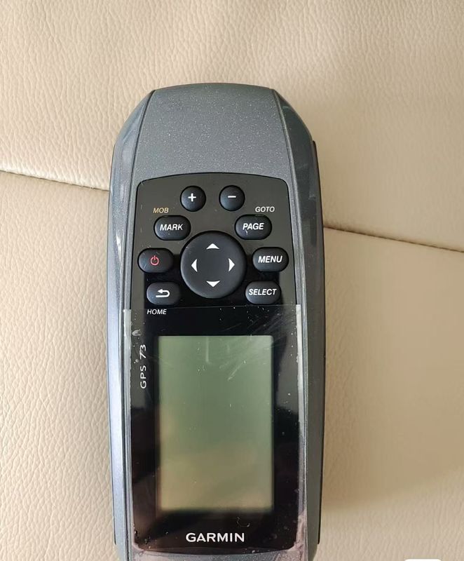
Easy-to-use GPS Handheld Navigator
High-sensitivity GPS marks and stores 1,000 waypoints and 100 tracks
Marks your favorite locations to easily navigate back to them
Garmin SailAssist™ for GPS 73 includes virtual starting line, heading line, countdown timers and tack assist
Sunrise/sunset, estimated time of arrival, other calculations and marine data
Built-in backlight
This easy-to-use handheld is the perfect navigational solution for boats, sailboats or small watercraft that do not have a chartplotter. It’s also ideal as an important emergency navigation backup for all vessels. Its high-sensitivity GPS marks and stores 1,000 waypoints and 100 tracks so you can navigate right back to them. Use on land or water — it floats! Features SailAssist, including virtual starting line, heading line, countdown timers, and tack assist.
Quickly Acquires Satellites
High-sensitivity GPS receiver quickly locks onto GPS signals and tracks your location even in challenging locations, such as deep canyons or under heavy tree cover.
Mark Important Waypoints
Whether it’s a hot fishing spot or a lobster pot, you can mark and store 1,000 waypoints and 100 tracks to navigate to and from time and time again.
SailAssist
SailAssist helps you sail more effectively with heading line and tack assist. Tack assist lets you know when to tack based on whether your boat is getting headed or lifted compared to the boat's optimal tacking angle. For those who like to race, there’s a virtual starting line and countdown timer to make sure you cross the starting line at the right time.
Store Important Data
GPS 73 is NMEA 0183 compatible. To transfer the data to your device, it easily connects to your computer via USB. If you're boating, hunting, or fishing, you can use the built-in celestial data, which includes sunrise/sunset times and a hunting and fishing calendar, estimated time of arrival, other calculations and marine data.
High-contrast Display
GPS 73 has an intuitive user interface with dedicated back-lit buttons for quick and easy operation. Its high-contrast display makes it easy to read in all lighting conditions.
Applications:
The Garmin GPS73 RTK GPS System is a versatile and reliable tool designed for various application occasions and scenarios. Whether you are an outdoor enthusiast, a professional surveyor, or a marine navigator, this product offers exceptional performance and features to meet your needs.
One of the key features of the Garmin GPS73 is its high-precision RTK GPS technology, which provides accurate positioning data for surveying, mapping, and navigation tasks. The device is suitable for use in the United States and offers reliable performance in diverse environments.
With a battery life of over 18 hours, the GPS73 ensures long-lasting power to support extended fieldwork sessions. The device operates on 2 AA batteries (not included), making it convenient to replace power sources when needed. Additionally, the IPX7 water rating ensures the GPS system remains functional even in wet or rainy conditions.
Equipped with the ability to store up to 1,000 waypoints, favorites, or locations, the Garmin GPS73 allows users to store important data and access it whenever required. Whether you need to mark specific points of interest, track your route, or save key locations, this feature enhances the usability and functionality of the device.
Compact and lightweight, the Garmin GPS73 weighs only 7.2 ounces (203.1 grams) with AA batteries, making it easy to carry and use during outdoor activities or fieldwork. The portable design ensures convenient handling without compromising on performance.
In summary, the Garmin GPS73 RTK GPS System is a reliable and efficient tool that caters to a wide range of application occasions and scenarios. Whether you need precise positioning data for surveying, mapping, or navigation purposes, this product delivers exceptional performance and reliability.
Customization:
Customize your Garmin GPS73 RTK GPS System to meet your needs with our Product Customization Services. Enhance your Garmin GPS73, a reliable and easy-to-use GPS handheld navigator, with personalized features tailored to your requirements.
Product Attributes:
- Brand Name: Garmin
- Model Number: GPS73
- Place of Origin: US
- Water rating: IPX7
- Weight: 7.2 Oz (203.1 G) With AA Batteries
- Battery type: 2 AA Batteries (not Included)
- Navigation Routes: 50
- Waypoints/favorites/locations: 1,000
Support and Services:
Product Technical Support and Services for the RTK GPS System:
- Troubleshooting assistance for hardware and software issues
- Software updates and patches to improve functionality
- Repair services for damaged or malfunctioning units
- Training and educational resources for users to optimize system usage
- Online resources such as manuals, FAQs, and user forums for self-help

 Your message must be between 20-3,000 characters!